|
| *****SWAAG_ID***** | 964 |
| Date Entered | 25/11/2016 |
| Updated on | 06/06/2017 |
| Recorded by | Tim Laurie |
| Category | Settlement |
| Record Type | Archaeology |
| SWAAG Site | Reeth Low Moor |
| Site Access | Public Access Land |
| Record Date | 10/09/2011 |
| Location | Reeth Low Moor, Cringley Bottom |
| Civil Parish | Reeth |
| Brit. National Grid | NY 997 003 |
| Altitude | 395m |
| Geology | See British Geological Survey England and Wales Sheet 41 Richmond. The uppermost strata of Cringley Hill and Calver Hill are the Richmond Cherts and the Main Limestone. The Middle Limestone outcrops on the Dale sides below Riddings Farm. |
| Record Name | Archaeological Landscapes of Reeth Low Moor. Cairnfield settlement complex below Cringley Hill |
| Record Description | References RTH01- are to the Sites Numbered on the SWALB EDM survey plan with later additions, Laurie et al 2011. For the full survey and and introduction to the Cairnfield Settlement Complex, the Coaxial Field System below Cringley Hill (Calverside West) and the settlements within the Barney Beck Pastures (from Nova Scotia to Low Cringley) see SWALB Survey attached and Laurie et al 2011.
Cairnfield extending from Fore Gill eastward to, beyond and below Cleasby Intake within the area of the coaxial field system recorded separately in this database. At least 75 stone cairns, usually more or less reduced by quarrying. This cairnfield survives on open moorland above the enclosed Barney Beck Pastures and are associated with short lengths of irregular field walling which are unconformable with the organised coaxial field boundaries (RTH012).
For record purposes, it has been assumed that the isolated large round cairn (RTH010) the cairnfield and the associated irregular field banks(RTH011) the Burnt Mound (RTH 006) represent the earliest phase of agricultural activity at Low Cringley and that the curvilinear enclosures (RTH005 and RTH 00*)and the co-axial field systems (RTH012 and RTH01*) represent a subsequent more managed landscape. Most of the cairns have been slighted by subsequent, probably recent, stone quarrying however it is significant that several cairns located at very close proximity to coaxial field banks have NOT been reduced to form the banks and therefore that the coaxial field system may have developed from the cairnfield stage of occupation.
All features other than the cairnfield and the associated short lengths of irregular field banks are recorded separately. The slight remains of the very large 19m diameter round cairn situated close to and quarried away for the modern pasture walls above Low Cringley Farm are recorded separately as RTH009. The two 8m diameter circular cairns which are relatively undisturbed at NY99765 00306 are photographed and identified separately as RTH011A and 011B as they are relatively well built, are distinctive and have visible kerbs.
No archaeological features are mapped within the walled pastures at Cleasby Intake, however it may be assumed that the cairnfield once extended across these pastures also.
|
| Dimensions | NY99765 00306 or 399765 500306 (centre) |
| Additional Notes | From experience elsewhere in Upland Britain, see References, there are reasons to conclude that the cairnfield below Cringley Hill should be the earliest agricultural activity on Reeth Low Moor predating the coaxial field system (RTH012) and may relate to Late Bronze Age or earlier settlement activity centred on the two large circular stone banked enclosures recorded separately as RTH005 and RTH017.
Equally there is evidence to conclude that the cairnfield was relevant and was an active element during the period of the occupation of the coaxial field system. There is no evidence that the small cairns were robbed for material to form the coaxial banks. For example, at Location RTH12 on the attached survey extract, a coaxial field bank passes within 5m distance from and directly between three small cairns. The same boundary passes close to at least three further cairns all of which are complete and unslighted
|
| Image 1 ID | 7054 Click image to enlarge |
| Image 1 Description | Calverside West. SWALB EDM survey plan with later additions, Laurie et al 2011. | 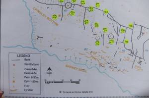 |
| Image 2 ID | 7055 Click image to enlarge |
| Image 2 Description | Calverside West. SWALB EDM survey plan, Laurie et al 2011. | 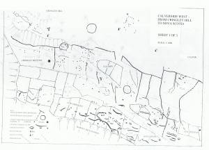 |

